Εμφάνιση αναρτήσεων με ετικέτα GIS. Εμφάνιση όλων των αναρτήσεων

Τρίτη 24 Φεβρουαρίου 2026

Εδώ θα βρείτε το κανάλι μου στο YouTube.


Το κανάλι ασχολείτε, κυρίως, με πτήσεις Drone που κατά καιρούς εκτελώ, είτε για επαγγελματικούς, είτε για ερασιτεχνικούς σκοπούς. Σκοπός είναι να δείξω στον χρήστη όμορφα τοπία και γεγονότα. Ελπίζω να σας αρέσει και φυσικά περιμένω προτάσεις, είτε για τη βελτίωσή του, είτε για νέες βιντεοσκοπήσεις.

Σάββατο 8 Νοεμβρίου 2014

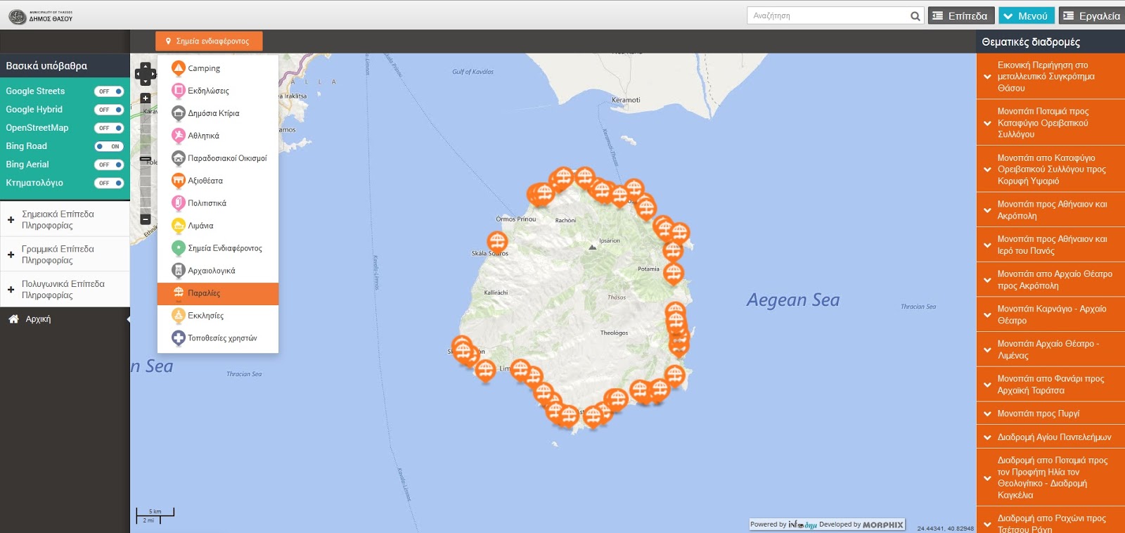
Οδηγός Θάσου (WebGIS of Municipality of Thassos)

Είμαι πραγματικά στην πολύ ευχάριστη θέση να παρουσιάσω ένα έργο όπως ο τουριστικός, και όχι μόνο, Οδηγός της Θάσου. Το έργο πραγματοποιήθηκε από την Infoδημ και τον Δήμο Θάσου στα πλαίσια της Ψηφιακής Σύγκλισης. Είμαι πολύ περήφανος που πήρα μέρος σε αυτό το έργο και ευχαριστώ την Infoδημ που μου έδωσε την ευκαιρία να συμμετάσχω σε ένα τόσο πρωτοπόρο έργο για τον ελλαδικό χώρο.

Κυριακή 30 Μαρτίου 2014

Free GIS Course: Skills for the Digital Earth

Skills for the Digital Earth
The Use of Location Technologies for All

Elmhurst College’s Skills for the Digital Earth MOOC (massive open online course) is a 4-week, online course designed to introduce how location technologies are used in society. The Digital Earth MOOC is being offered through Desire2Learn (D2L) Open Courses.

Run Dates: March 30 - April 26, 2014 (4 weeks)
Registration Opens: March 3, 2014
Cost per student: Free


Σάββατο 25 Ιανουαρίου 2014

ΜΕΛΕΤΗ ΠΡΟΣΤΑΣΙΑΣ ΚΑΙ ΔΙΑΧΕΙΡΙΣΗΣ ΔΗΜΟΣΙΟΥ ΔΑΣΙΚΟΥ ΣΥΜΠΛΕΓΜΑΤΟΣ ΛΙΒΑΔΕΡΟΥ – ΜΥΡΣΙΝΕΡΟΥ – ΑΕΤΟΥ – ΞΗΡΟΠΟΤΑΜΟΥ – ΚΑΛΛΙΦΥΤΟΥ – ΜΟΝΑΣΤΗΡΑΚΙΟΥ Π.Ε. ΔΡΑΜΑΣ ΔΙΑΧΕΙΡΙΣΤΙΚΗΣ ΠΕΡΙΟΔΟΥ 2014-2023

ΣΥΝΤΑΚΤΕΣ: (ΔΑΣΑΡΧΕΙΟ ΔΡΑΜΑΣ)

ΚΑΡΑΓΙΑΝΝΙΔΗΣ ΑΒΡΑΑΜ, ΔΑΣΟΛΟΓΟΣ
ΛΕΠΙΔΗ ΑΝΑΣΤΑΣΙΑ, ΔΑΣΟΛΟΓΟΣ
ΤΣΙΡΙΔΗΣ ΑΛΕΞΑΝΔΡΟΣ, ΔΑΣΟΛΟΓΟΣ

ΟΜΑΔΑ ΠΕΔΙΟΥ:

ΕΥΑΓΓΕΛΟΣ ΒΑΛΣΑΜΙΔΗΣ, ΔΑΣΟΠΟΝΟΣ
ΣΑΒΒΑΣ ΚΑΖΑΝΤΣΟΓΛΟΥ, ΔΑΣΟΛΟΓΟΣ
ΠΑΡΑΣΚΕΥΑΣ ΝΙΚΟΛΑΟΥ, Msc ΔΑΣΟΛΟΓΟΣ
ΑΘΑΝΑΣΙΟΣ ΣΑΠΑΝΙΔΗΣ, Msc ΔΑΣΟΛΟΓΟΣ
ΑΝΔΡΕΑΣ ΣΟΦΡΑΣ, ΔΑΣΟΛΟΓΟΣ
ΑΝΕΣΤΗΣ ΤΣΑΚΙΡΙΔΗΣ, ΔΑΣΟΛΟΓΟΣ

ΠΕΡΙΛΗΨΗ

Οι εξελίξεις τόσο στο τεχνολογικό, όσο και στον επιστημονικό τομέα, δεν αφήνουν αδιάφορη τη δασική επιστήμη, μέρος της οποίας είναι και η δασική διαχειριστική. Η δασική διαχειριστική ασκείται σχεδόν 5 δεκαετίες και ορίζεται από προδιαγραφές που ισχύουν όλα αυτά τα χρόνια. Είναι επιτακτική ανάγκη να αλλάξουν οι προδιαγραφές αυτές και ήδη υπάρχουν νέες σκέψεις στο θέμα αυτό. Οι νέες προδιαγραφές θα πρέπει να στηρίζονται στην αειφορική διαχείριση των πολλαπλών χρήσεων ή σκοπών, όπως επιτάσσει η παγκόσμια τάση. Πλέον, η αειφορία της ξυλοπαραγωγής θεωρείται ξεπερασμένη και θα πρέπει να δίνεται σημασία στα υπόλοιπα προϊόντα του δάσους και τις λειτουργίες του. Στην κατεύθυνση αυτή κινείται και η παρούσα Μελέτη Προστασίας και Διαχείρισης. Θέλοντας να εφαρμόσει πολλαπλών χρήσεων διαχείριση στη περιοχή μελέτης, που είναι το Δημόσιο Δασικό Σύμπλεγμα Λιβαδερού – Μυρσινέρου – Αετού – Ξηροποτάμου – Καλλιφύτου – Μοναστηρακίου της Περιφερειακής Ενότητας Δράμας (Διαχειριστικής Περιόδου 2014-2023). Για να ολοκληρωθεί η διαχείριση, προτιμήθηκε η λύση των Γεωγραφικών Συστημάτων Πληροφοριών (ΓΣΠ). Οργανώθηκε με όλα τα απαραίτητα η Γεωβάση Δεδομένων, αφού προηγήθηκε συλλογή, επεξεργασία, ταξινόμηση και επέκταση των δεδομένων. Ακολούθησε η χρήση των χωρικών δεδομένων που προέκυψαν, στη λήψη διαχειριστικών μέτρων βάσει την αειφορία των πολλαπλών χρήσεων και την χωρική τους κατανομή.

Λέξεις κλειδιά: διαχείριση, πολλαπλές χρήσεις, πολλαπλοί στόχοι, αειφορία, Γεωγραφικά Συστήματα Πληροφοριών.

Κυριακή 29 Σεπτεμβρίου 2013

Webinar: 13 Ways to Avoid a Raster Disaster

It can be difficult to master raster data and prepare it to your exact specifications. To avoid a raster disaster, join our webinar to see how you can:
  • Restructure raster data by clipping, mosaicking, tiling, and more
  • Create more valuable rasters by integrating data from other sources
  • Convert rasters into the format and coordinate system you need


Παρασκευή 6 Σεπτεμβρίου 2013

The Map Suite GIS Editor Has Been Released!


The beta period for Map Suite GIS Editor has ended and we would like to take this opportunity to thank everyone for their participation. As of today, we've launched an updated version of the GIS Editor that adds numerous new features, improves performance and squashes bugs. And, as a token of our appreciation, those of you who tested the GIS Editor during the beta will receive a free subscription to the new release of the GIS Editor good through the end of September.

Κυριακή 11 Αυγούστου 2013

Webinar: Multi-Language Discovery of Big Data for Mission Success

 
Security threats and incidents can arise in an instant, and the availability of real time on-the-ground intelligence can mean the difference between life and death. In addition to leveraging traditional classified intelligence sources, responders and analysts often turn to Open Source Intelligence (OSINT) gleaned from news feeds, blogs and social media to help predict where an incident may occur, understand what’s happening on the ground and manage and mitigate repercussions.

However, as the Web contains countless sources of information in myriad languages, analysts and decision-makers rarely have the time or resources for manual translation processes. How can users sift through the Web’s vast, multi-language repository of open-source content to locate the intelligence that is most relevant to the mission at hand? A qualified Human Translator can translate up to 2500 words per day. Statistical Machine Translation (SMT) language engines can translate up to 2500 words per minute, per CPU.

Πέμπτη 8 Αυγούστου 2013

WEBINAR: KML 101 – How to Create Amazing Maps in Google Earth and Maps

Overview

Find out how to transform virtually any data into KML – regardless of format or structure – using FME. You'll see how to easily create and style balloons, customize icons and colours, as well as intelligently organize placemarks – all using repeatable processes that let you create amazing displays in Google Maps and Earth. Plus discover how to share real-time data by using FME with HTML5 WebSockets.

Παρασκευή 2 Αυγούστου 2013

ArcGIS 10.2 Brings Transformational Capabilities to Users

ArcGIS Online Functionality Now Available On Premises

Highlights

  • ArcGIS Online capabilities become part of the on-premises platform.
  • Real-time mapping and GIS keep users synced with the real world.
  • Location analytics equals more accurate business intelligence.
  • New developer opportunities are available on the ArcGIS platform.
Portal for ArcGIS allows users to configure and deploy ArcGIS Online capabilities on premises—enabling organizations to easily integrate GIS everywhere.
It's a great time to be a GIS professional. Dramatic changes are taking place in the enabling computing and communication technologies that GIS relies on, and new software is leveraging these changes to evolve and transform GIS and our user community. Esri is working hard and is in the process of releasing many new capabilities in ArcGIS 10.2, such as real-time data integration, online analysis tools, spatial analysis in the cloud, location analytics, new templates and apps, and web story maps for everyone. There are also new capabilities enabling new opportunities for developers. These advances are giving rise to a change in the very way we position GIS, from a software system designed to unlock the power of geographic information to a comprehensive platform that promises to transform your work; your organization; and, ultimately, our world.

Πέμπτη 7 Μαρτίου 2013

WEBINAR: How to Efficiently Transform Non-Spatial Data

Wednesday, March 13 at 8am PDT / 11am EDT / 3pm GMT

Overview
Level: Introductory


FME supports a wide range of non-spatial data, from spreadsheets (CSV, Excel) to databases (SQL Server, Oracle) and to key applications (Salesforce, Socrata). In this webinar, discover how to easily transform non-spatial data for use, even adding a spatial component to your non-spatial data. You'll also hear how SYNCADD has been using FME to solve non-spatial challenges in a variety of situations.

While FME is best known for its spatial proficiency, it's also a powerful solution for non-spatial, letting you solve a more complete range of data challenges with one tool.


Τετάρτη 3 Οκτωβρίου 2012

Webinar: Introduction to ArcGIS for Local Government


Learn the Basics in Just One Hour

Introduction to ArcGIS for Local Government

Thursday, October 4, 2012
9:00 a.m., 11:00 a.m., and 3:00 p.m. (PDT)

Join us for this online seminar to learn how to use the maps and apps in this new solution to meet your organization's business needs.

Instructions for Viewing the Seminar
  • Log in up to 30 minutes before the seminar begins.
  • You will need an Esri Global Account. If you don't have one, you can create one now.

Are you unable to attend the live seminar? View it in the recorded seminars archive shortly after the live session.

Σάββατο 1 Σεπτεμβρίου 2012

Webinar: Portray Your Geography to the World

Geospatial organizations need to use and distribute volumes of geospatial data, but disparate legacy information systems may hinder data sharing. When departments use different geospatial software and data formats, data silos result, forming obstacles to effective collaboration within the enterprise. Additional problems arise when trying to share data with outside organizations.


Πέμπτη 19 Ιουλίου 2012

Release of the free GIS Cloud Publisher extension for Esri ArcMap

A single click solution to get your maps from desktop to the Cloud!

The extension is free and compatible with Esri ArcMap 9.x and 10.x. You can download it from the following link: GIS Cloud Publisher for ArcMap (600kB)

Publishing GIS projects with traditional GIS tools is not easy. You have to set up your own server, being that a server from a commercial vendor or open-source, and follow that with maintaining the server and services, uploading your data from desktop, reconfiguring maps and generating tiles to be optimized for the Web, not to mention mobile and tablets. All these are, for the most part, daunting and/or expensive tasks.

Παρασκευή 13 Απριλίου 2012

Webinar: TerraGo Toolbar v.6 - Raising the Bar for Geospatial Collaboration

TerraGo® Technologies, the pioneer of patented methods and systems for encoding geographic coordinates and features in a PDF file, has once again raised the bar for geospatial collaboration with the introduction of TerraGo ToolbarTM v.6.
Join TerraGo for a webinar on Tuesday, Apr. 17 at 2:00 p.m. Eastern to see how TerraGo Toolbar enables any user, regardless of their access to sophisticated GIS or training, to dynamically update and share compact geospatial information from any source and roundtrip it back to the enterprise GIS.


Τρίτη 10 Απριλίου 2012

ΧΑΡΤΟΓΡΑΦΙΑ ΓΙΑ ΠΑΙΔΙΑ: ΠΡΟΣΚΛΗΤΗΡΙΟ ΒΑΠΤΙΣΗΣ

Η Χαρτογραφία είναι η απόδοση του πραγματικού κόσμου σε δύο διαστάσεις. Είναι η ανάγκη αποτύπωσης και απόδοσης των χωρικών δεδομένων και των ιδιοτήτων τους. Τα χωρικά δεδομένα αποτυπώνονται στους χάρτες με τρεις μορφές: ως σημεία, γραμμές ή πολύγωνα, ανάλογα πως αντιλαμβάνεται ο δημιουργός του χάρτη τα χωρικά δεδομένα και τι θέλει να πετύχει, αλλά και το πως αντιλαμβάνεται ο αναγνώστης ευκολότερα τις ιδιότητες ενός χωρικού δεδομένου.

Ένας χάρτης μπορεί να αποδίδεται σε δύο διαστάσεις (πχ. αποτύπωση και απόδοση σε χαρτί), ωστόσο μπορεί να περιέχει στοιχεία παραπάνω διαστάσεων. Οι δύο διαστάσεις αφορούν το μήκος και το πλάτος, όπως αναφέρθηκε όμως μπορεί ένας χάρτης να περιέχει και στοιχεία υψομετρικά, ακόμα και να αποδόσει τη χρονική διάσταση ενός φαινομένου που καταλαμβάνει χωρική διάσταση.

Τετάρτη 28 Μαρτίου 2012